

I will never forget my days during the Open Street Map project in Ggaba Parish. It all started on Wednesday 5th-sept-2018 at Ggaba beach hotel. We were introduced to the Map Uganda team and the Humanitarian OPenStreetMap Team (HOT); Mr.Rupert and Mr.Geofry. With them, there was also a member of the World Bank; Mr.Chris.
Individually, i am a community member of Ggaba Parish though I was to also work as a surveyor/data collector together with four other community members as contracted by Map Uganda.
Amongst us were local leaders from some zones of Ggaba Parish such as Ggaba Trading center, Ggaba water and Ggaba Katoogo. KCCA, UBOS and OPM also had their members on board. All members were exceptionally polite and friendly which made me realize how hospitable the environment was.
We underwent a two days training and in the due course, we gained a wider understanding of OSM(Open Street Map) together with Geospatial data collection plus the use of OSM tools like OSMAnd, ODK(Open Data Kit) and Open Map Kit.
Our key duties were;
Collecting data for disaster response in Ggaba Parish-Makindye division i.e roads, drains/ditches, buildings, POIS (Points Of Interest) and flood prone areas.
Tracking the routes passed during the data collection exercise and reporting any incident in the field.
In the field
On Friday 7th-Sept-2018, we hit the field starting with Ggaba Trading Center then for the next days we spread to the other zones of Ggaba Katoogo, Ggaba water and Ggaba mission.
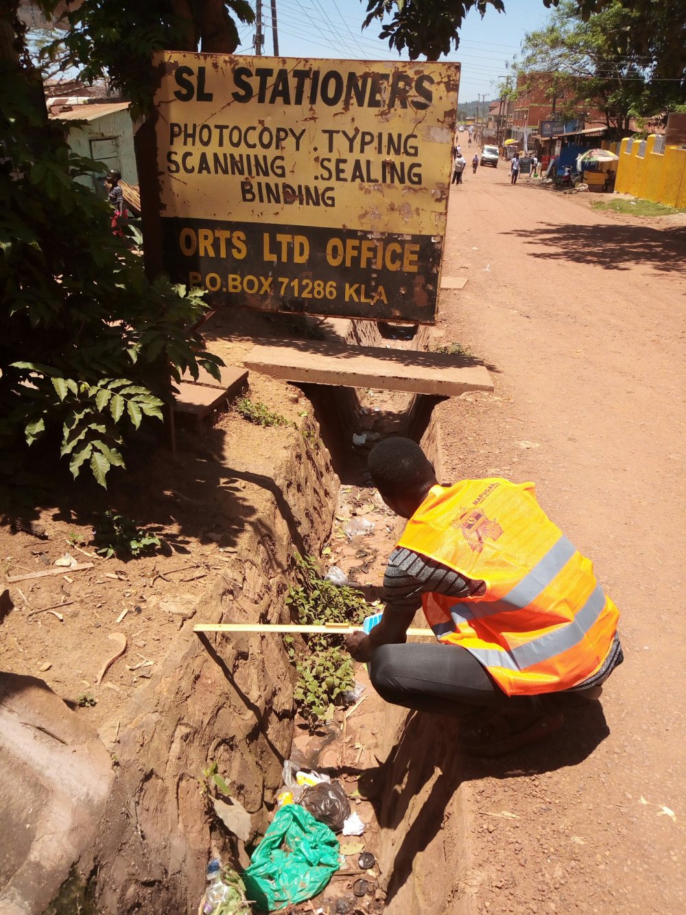
Before heading to the field every morning, we were given reflector jackets labeled Map Uganda, tape measures, long rulers, identity cards, introduction letters and smart phones that had data collection Applications. The fact that we had reflector jackets captured public attention which kept them wondering about our motives. Many people approached me and were so inquisitive of our mission because apparently majority thought we were from KCCA or NEMA which agencies they were biased of but I was able to handle them professionally hence keeping them at ease.
Though some people were hostile, giving them a thorough explanation of our aims and goals was an added advantage. They wanted to know how the project was to benefit them. Therefor telling these people that through the act of data collection, we wanted to know the state of all drains, buildings, general sanitation and flood prone areas for disaster response purposes left them assured that there is hope of helping them improve their living conditions and standards. The local people craved for better services so that issues of flooding, poor toilet facilities, improper waste disposal, poor drainage and pathways (for easy access to their homes even by the fire department in case of a fire outbreak) are addressed.
Collecting data was not a hard task given the fact that we were using smart phones which had tools like OSMAnd, ODK and Open Map Kit therefor there was no need of interviewing locals since it was all about using eyes and smartphones. It was even much easier when mapping buildings, drains and points of interest.
However, the case was different when it came to getting information on flood history. It is the residents that had the most correct information on flood prone points. Therefor I had to ask them share the information.
The data collection exercise led me to all corners of the community and one day I found myself at someone’s shrine. I kept calm but very nervous. However, after explaining in detail the kind of work I was doing at the moment, the witch doctor gave me all information I needed about flood history in her residence and I left. A few meters from the shrine, I landed into 3 dogs that barked at me hence forcing me to run in fear of being bitten. Thank God I had already collected the data I wanted.
When it came to mapping Katoogo zone, the local leaders were cooperative since we explained in detail and illustrated how OSM tools work. However, most people in this zone put on hostile faces when they saw strangers wearing reflector jackets. They thought we were from KCCA or NEMA and had come to evict them, but after seeing us with their local leaders, they were convinced that we meant no harm. Many people in this zone live under poor conditions such as wooden houses with swamp water beneath, they have poor toilet facilities and improper waste disposal.

When it came to mapping National water plant area, we were given a lot of hard time accessing the area since a lot of procedures had to be followed. At first, I was with the executive director of Map Uganda, Miss Tinah. She worked so hard and returned with the access authorization papers after some time. The next day we mapped the water plant area but the place was too big moreover under the scotching sun with nowhere to hide though we were able to successfully accomplish our mission.
According to what we found and saw in the field, many drains where not in a good state, they were broken, filled with rubbish and dirt. It was even worse when it came to ditches; they were unplanned and in a poor state especially in katoogo zone.
Most buildings were old and weak therefor can not withstand a heavy storm incase it strikes. The fact that most houses are tightly packed, passage and access can be a challenge especially by vehicles.
I also came to realise that many places in Ggaba are prone to flooding mainly because of lack of planned wellbuilt drains, unleveled ground, blockage of drains/ditches and building in the swamp.
How i benefitted from the project
Days in the OSM Ggaba project gave me an inspirational and motivational experience. I was blessed with the opportunity of gaining deeper understanding of OSM, how to use data collection tools like ODK, Open Map Kit and OSMAnd. In the due course of the exercise, my data collection skills were boosted, I gained field experience, better interpersonal skills and also got new and stronger professional skills like professional etiquettes and work ethics.
I also got to understand how important time management and team work are. We were doing everything on time so as to hit our target goals. Where it required providing an extra hand to team members for them to accomplish their tasks, we had to cooperate.
I was exposed to real life challenges and issues in the community that are perhaps not theoretical. This made me realize how much our communities are in need of better services and help from service providers.
Networking with professionals from Map Uganda, HOT, World Bank, KCCA, UBOS and OPM helped me seek guidance and mentorship in the field of OSM. The network can also be a key to my future job opportunities.
Importance of the project to the community
Points of Interest in Ggaba parish being added on map is an advantage since it boosts their being known hence free marketing.
The ground visits made will improve access to collected information that can be used to quicken decision making process by service providers for places like Ggaba.
The data collected can help communities understand their environment since even community members and local leaders were involved in the exercise.
After the exercise being carried out, there is hope of reducing disaster risks in Ggaba Parish since everything on ground is now known.
In conclusion
I am truly grateful to Map Uganda, HOT and World Bank for the incredible opportunity they gave me to join their team. Thank you.
I also extend my heartfelt appreciation to the field team who worked tirelessly to bring good data from the field. Thank you for the support, guidance and endless love.
I owe much gratitude to the project manager Mr.Hillary who labored so much to guide us and motivate us with his immense insights and creativity. Thank you so very much.
Working in the OSM Ggaba project was more than just earning financial credit, it was an opportune time to learn from the experienced team which boosted my passion. I therefor look forward to working with you if opportunity ever presents itself again.


Great blog Paul. Really enjoyed reading it. We shall meet…!
Best, Rupert
LikeLiked by 1 person
Thanks Rupert 😀. I really want to work with you guys again. You are an amazing team
LikeLike